Skip the crowds. Mahanoro offers raw coastal beauty, canal boat rides, and easy access to the Mangoro River in Madagascar’s Atsinanana region.
The road from Vatomandry to Mahanoro requires patience. For 46 kilometers, the asphalt gives way to corrugated earth, dust, and the occasional pothole deep enough to test the suspension of even the sturdiest 4x4. This terrain serves as the first lesson of the Atsinanana region. Mahanoro, a small town on Madagascar’s eastern coast, rewards attention over speed. When you finally arrive, the noise of the engine fades into the rhythmic lapping of the Indian Ocean against the shore. The air here is thick with salt and the green scent of rainforest runoff. There are no luxury resorts lining the beach, no neon signs, and no queue for entry. There is only the town center, the beachfront, and the vast, quiet geography that defines this part of the island.
Between the Canal and the Sea
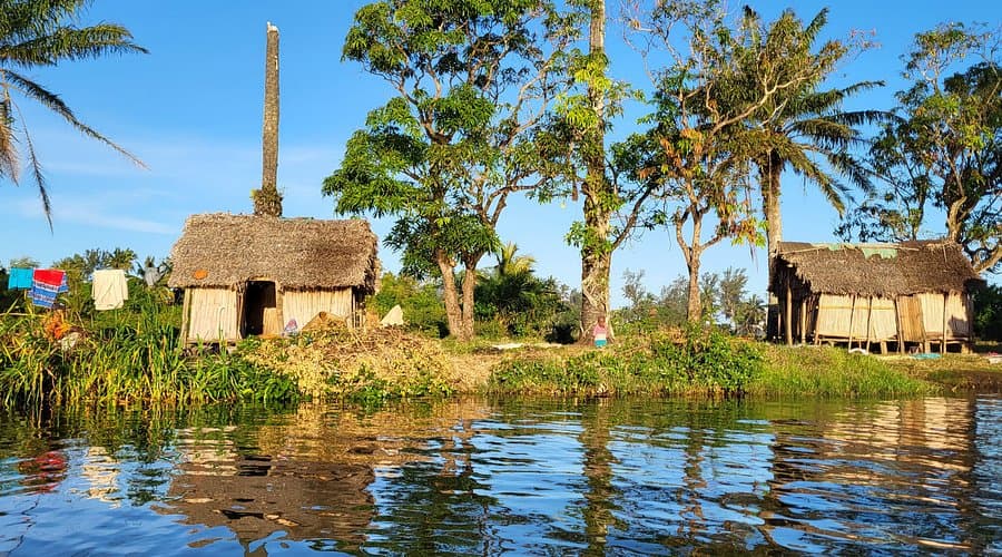
Mahanoro’s geography is its primary attraction. The town sits in a narrow strip of land between two major water bodies: the Indian Ocean to the east and the Canal des Pangalanes to the west. This positioning makes Mahanoro a natural hub for boat transport and a scenic stop for travelers moving along the coast. The Canal des Pangalanes, the world’s longest freshwater canal, runs parallel to the coast, offering a different perspective of the landscape than the road does. From the town, you can see the contrast between the blue expanse of the ocean and the calm, green waters of the canal. This duality defines the local rhythm. Life here is oriented toward the water, whether for transport, fishing, or simple daily routine. The beachfront is accessible and walkable, providing a quiet space to watch the day unfold. It is a functional, natural shoreline where locals gather and the tide dictates the schedule.
The Mangoro River and Natural Access
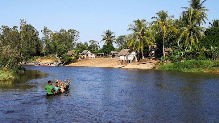
Just nine kilometers north of the town center lies the mouth of the Mangoro River. This major geographical feature is a key draw for those interested in nature and gentle adventure. The river flows from the interior highlands, cutting through dense rainforest before emptying into the ocean. For travelers, the Mangoro River offers opportunities for boat trips that explore the delta and the surrounding wetlands. These trips are flexible excursions that depend on the tide, the weather, and the availability of local boats. The scenery along the river is lush and largely untouched, providing a stark contrast to the arid landscapes of the island’s west. The water is calm, and the birdlife is abundant. It is a place to slow down and observe. The lack of heavy infrastructure means that the experience is raw and authentic. You are not visiting a park; you are entering a living ecosystem.
Getting Around: Road and Water
Access to Mahanoro is primarily by road. The town is located 46 kilometers north of Vatomandry, a larger town that serves as a regional hub. From Vatomandry, you can hire a taxi or a private driver. The journey takes about an hour, depending on road conditions. Further south, Mananjary is 209 kilometers away, a longer trip that typically takes a full day by road. Marolambo is 136 kilometers to the south. These distances are significant in a country where road travel is slow and often unpredictable. It is important to plan your transit with flexibility. Do not book tight connections. Allow for delays due to weather, road repairs, or vehicle issues. Boat transport is also an option via the Canal des Pangalanes. This mode of travel is slower than road transport but offers a unique view of the coastline and the interior. Boats are often shared, and schedules are informal. It is a way to travel that connects you with local life, rather than isolating you from it.
Food and Daily Life
There are no confirmed local dishes unique to Mahanoro. The food here is part of the broader Malagasy culinary tradition. You will find staples like Romazava, a stew made with meat (often beef or goat) and leafy greens, and Vary Amin’anana, a dish of rice cooked with pumpkin. Akoho Rony, chicken cooked in a sour sauce, is also common. These dishes are prepared in local homes and small eateries in the town center. The ingredients are fresh and local, reflecting the agricultural output of the region. Rice is the central element of every meal. Meals are simple, affordable, and satisfying. There is no fine dining scene here, but there is a genuine connection to the land and the food that comes from it. Eating in Mahanoro is an act of participation in daily life. You are not a spectator; you are a guest at the table. The etiquette is straightforward: wash your hands before eating, and eat with your right hand if utensils are not provided.
When to Go and Who It’s For
The best time to visit Mahanoro is during the dry season, from April to October. During these months, the roads are more passable, and the weather is generally pleasant. The summer months in the Southern Hemisphere (December to February) bring heavy rains and cyclones, which can disrupt travel and make road conditions difficult. If you are planning to visit in June, be aware of upcoming holidays. Father’s Day is celebrated on the third Sunday of June, and Independence Day is on June 26. These dates may see increased local activity and demand for transport and accommodation. Book early if you plan to travel during this period. Later in the year, Assumption Day (August 15), All Saints’ Day (November 1), and Republic Day (December 18) are also significant. Mahanoro is best suited for slow travelers, solo adventurers, and those interested in nature and culture. It is not a destination for luxury seekers or those who require constant entertainment. A stay of two to three days is sufficient to experience the town, the beach, and the river. It is a place to breathe, not to rush.
Practical FAQ
Is it safe to travel to Mahanoro? Yes, Mahanoro is generally safe for travelers. Standard precautions apply: be aware of your surroundings, secure your belongings, and respect local customs. The main risks are related to road conditions and health, not crime.
What currency should I use? The Malagasy Ariary (MGA) is the local currency. Cash is king in small towns like Mahanoro. ATMs are scarce, so bring enough cash from larger cities like Vatomandry or Antananarivo.
Do I need a visa? Travelers should check the latest visa requirements for Madagascar before their trip. Visa policies can change, and some nationalities may require a visa on arrival or an e-visa. Always verify with official government sources.